|
September 23, 2005
New Management Plan RELEASED for
Los Padres National Forest
Revised
Guidelines Will Govern Development
Activities on the Forest for the Next Decade
The U.S. Forest Service has released
a new
land management plan for the Los Padres National Forest and
three other national forests in southern California. The new
plan covers all 1.76 million acres of the Los Padres, and will guide decisions on everything from protecting wildlife
and providing recreation opportunities, to deciding where
potentially damaging development can take place.
ForestWatch criticized the plan for not going far
enough to address challenges that threaten the natural and
recreational values of the Los Padres.
Below is our preliminary analysis of the plan. We
encourage folks to attend one of the agency's open houses in
October (see schedule to the right) to find out more. In the
meantime, if you'd like to view the agency's documents and maps,
click the "View Documents" icon towards the top of this page.
Wilderness Areas & Recreation
The Los Padres currently contains 10 wilderness
areas across 48% of the forest's land base. Wilderness
designation is the best way to permanently protect forest lands
and to accommodate rising demand for wilderness recreation.
 The new plan recommends wilderness protection for
only four areas totaling 35,821 acres in Santa Barbara and
Ventura counties. This amount represents just 2% of the forest's
land base. The agency failed to identify any new wilderness areas in San Luis Obispo or Monterey counties. The new plan recommends wilderness protection for
only four areas totaling 35,821 acres in Santa Barbara and
Ventura counties. This amount represents just 2% of the forest's
land base. The agency failed to identify any new wilderness areas in San Luis Obispo or Monterey counties.
The new plan
recommends adding this area along
Mono Creek to the existing Dick Smith Wilderness.
The areas recommended for wilderness
in the new plan include:
- Dick Smith Wilderness Additions
(32,273 acres) -
Two areas about 10 miles north of Santa Barbara, near
Buckhorn and Mono creeks. If approved by Congress, these
areas would be added to the existing Dick Smith Wilderness
area.
- Matilija Wilderness Addition
(2,822 acres) - A
small area six miles northwest of Ojai in Ventura County. If
approved by Congress, this area would be added to the
existing Matilija Wilderness.
- Chumash-Toad Springs
(726 acres) - This is an
old off-road vehicle corridor that cuts through the middle
of the existing Chumash Wilderness area in Ventura and Kern
counties. Under previous legislation passed by Congress,
this area is automatically added to the Chumash Wilderness
as soon as the agency creates an alternate OHV route.
The agency
even retreated from it's draft plan, slashing 11,000 acres of
wilderness that it recommended just last year. ForestWatch
will work to ensure that additional areas are recommended for
wilderness protection.
Read more
about how the plan affects wilderness areas.
MORE
>>
Roadless Areas
The Los Padres contains nearly 600,000 acres
of pristine, roadless areas representing the last remaining
untouched wildlands in the forest. These roadless areas
contain many of the same qualities as official wilderness, but
are not yet officially designated as such.
The plan opens up 74% of these roadless areas
to new road construction. The plan zones 443,000 acres of
Inventoried Roadless Areas as Back Country, Back Country Motorized Use
Restricted, or Developed Area Interface, all of which allow
varying levels of road construction and development.
It is vitally important that the Forest
Service designate more roadless areas of the forest as
Recommended Wilderness or Back County Non-Motorized. This zoning
would ensure that no new roads are built in these pristine
areas, which were left unprotected when the administration
recently repealed the Roadless Rule.
MORE
>>
Clean Water Supplies
The plan recommends three river stretches for
protection under the Wild & Scenic River Act. These rivers
include:
- Arroyo Seco River - The plan
recommends protecting the entire 18-mile stretch of the
Arroyo Seco River, near the Ventana Wilderness in Monterey
County. This river flows by steep canyon walls, gorges, rock
outcrops, and deep pools. It also provides habitat for threatened steelhead.
- Upper Sespe Creek - The lower 31.5
miles of Sespe Creek are already protected under the Wild &
Scenic River Act. The plan recommends protecting an
additional 11.5 miles of Sespe Creek immediately upstream of
this area, from Chorro Grande Creek to Rock Creek. This
stretch contains one of the largest populations of
endangered arroyo toads, and also provides outstanding
habitat for steelhead and the southwestern willow
flycatcher. It's also located along the scenic Highway 33 in
Ventura County, a popular recreation destination.
- Upper Piru Creek - The plan
recommends 38.6 miles of Piru Creek for Wild & Scenic River
designation, from the headwaters in the Sespe Wilderness to
the upper limit of Pyramid Lake in Ventura County. This
year-round stream contains excellent fishing and other
recreation opportunities and several outstanding Native
American sites.
 The agency will now have to manage these
rivers to protect their wild and scenic values until Congress
officially grants protection under the Wild & Scenic Rivers Act. The agency will now have to manage these
rivers to protect their wild and scenic values until Congress
officially grants protection under the Wild & Scenic Rivers Act.
Unfortunately, the Forest Service identified a
total of seven streams in the Los Padres that are eligible for Wild
& Scenic River protection, but selected only these three. Find
out which streams the agency failed to recommend for Wild &
Scenic River designation.
MORE
>>
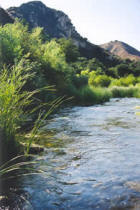
Piru
Creek, recommended for Wild & Scenic River protection.
Oil & Gas Drilling
The new plan incorporates the administration's
decision in July to open up 52,075 acres of the Los Padres to
oil drilling. The new plan incorporates this decision in full,
even though it was approved under the old Forest Plan and is
currently under appeal by the California Attorney General's
Office and three conservation groups, including ForestWatch.
Click here for the latest news regarding the
oil drilling decision and our appeal.
MORE >>
Wildlife Protection
The new plan identifies 12 "management
indicator species" (MIS). These species reflect the health of
entire ecosystems - if these species are declining, then the
entire ecosystem is not properly functioning. The Forest Service
monitors MIS to ensure that existing or proposed development
activities do not damage other species with similar habitat
requirements. Because of their surrogate status, MIS play a
vitally important role in ensuring healthy ecosystems and
avoiding habitat damage.
 The new plan selects 12 management indicator
species to monitor the health of various habitats. The plan
eliminates steelhead as a MIS, even though it was included in
the previous forest plan and is an excellent indicator of
aquatic habitat quality and overall watershed integrity. The new
plan also omits other important species from the MIS list. The new plan selects 12 management indicator
species to monitor the health of various habitats. The plan
eliminates steelhead as a MIS, even though it was included in
the previous forest plan and is an excellent indicator of
aquatic habitat quality and overall watershed integrity. The new
plan also omits other important species from the MIS list.
The new plan also provides inadequate
protection for streamside riparian habitats. The plan
establishes buffers to protect streams from nearby development
activities, but contains a loophole that allows development
closer to these sensitive areas simply "if a need is
identified." Design Criteria, Appendix E, p.65.
This is just one of many examples where the
agency establishes a guideline, but also establishes a loophole
that allows the agency to sidestep the guideline whenever it
wants to.
ForestWatch will work to ensure that the new
plan contains stronger, enforceable standards without
unnecessary loopholes. This is the only way to guarantee that
the agency will live up to its word.
Off-Highway Vehicles
The new plan continues the
agency's existing policy of restricting OHVs to designated trails.
This prevents erosion and damage that occurs when OHVs illegally
leave the trails.
Despite this longstanding
policy, irresponsible OHV enthusiasts have cut several illegal, unauthorized
trails through the forest. The agency has counted 160 miles
of illegal OHV trails in the Los Padres.
Instead of requiring the
immediate closure and rehabilitation of these illegal routes,
the plan requires the Forest Service to analyze each of these
illegal routes and (1) incorporate them into the official OHV
route system, or (2)
close and decommission the illegal road.
The Forest Service admits that
it doesn't have enough staff and resources to monitor all of the
existing legal OHV routes. ForestWatch will work to
ensure that the agency spends its scarce resources on monitoring
and enforcement of existing OHV routes, not on opening
even more (illegal) routes to the system.
Monitoring
The new plan requires the agency to prepare a
"program of work" each year, and to consistently monitor forest
conditions. Monitoring ensures that existing activities do not
unnecessarily damage the forest, and allow corrective actions to
be taken before such damage becomes permanent.
Most importantly, monitoring provides the
public with evidence that the new forest plan is (or is not)
working. ForestWatch will review
this monitoring data every year to ensure that the agency is
living up to its promises.
What's Next
The new forest plan becomes effective in late
October 2005. All activities and project approved after this
date must comply with the new forest plan.
Our staff is busy
peering through the thousands of pages of documents so that we
can determine exactly how this new plan will affect our national
forest. We remain optimistic that it's a step in
the right direction, but it appears that the
new plans do not go far enough to protect our public lands.
The agency
will sponsor several workshops in October in communities near
the forest, including Salinas, Big Sur, Arroyo Grande, Goleta,
Ventura, and Frazier Park. ForestWatch will attend these
workshops, and we encourage you to join us as we ask the agency
some tough questions about why it did not enact stronger
protections.
Conservation groups will have 90 days to appeal
the decision. ForestWatch will work in coalition with other
conservation groups to review the new plan in its entirety. If
we determine that the plans are a far cry from what is truly
needed for forest protection, then you can bet we'll take action to protect our public lands. |