|
May 8, 2006
BLM Announces Another Land
Giveaway of 19,600 Acres to Oil Companies
34 Parcels
Slated for Auction in Kern, Ventura, SB, and SLO Counties,
Including Lands Along the National Forest Boundary
The U.S. Bureau of Land Management has announced its final
decision to auction off 19,600 acres of land to oil companies
in June. The move could pave the way for oil drilling along the
boundary of the Los Padres National Forest, nearby public
lands like the Carrizo Plain National Monument and the Bitter
Creek National Wildlife Refuge, and privately-owned farmlands.
Last month, the BLM prepared an
Environmental Assessment for the lease sale. ForestWatch
submitted a detailed letter to officials, outlining several
legal and scientific inadequacies in the agency's analysis.
Unfortunately, the agency has decided to ignore most of our
concerns and has decided to proceed with the land auction, even
though the agency has not satisfied strict legal requirements
designed to protect wildlife, clean air and water, prime
farmlands, and floodplains from damage caused by oil drilling.
Oil companies will be
able to bid on the rights to extract oil and gas from these
parcels. The drilling rights will go to the highest bidder, with
minimum bids starting at only $2.00 per acre.
Many of the lands slated for
auction are located along main access routes leading into the
national forest. Most of the parcels are undeveloped, and many
are under cultivation by farmers. Allowing a network of oil
rigs, pipelines, and transmission wires will significantly
change the landscape of this rural area.
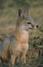
According to the agency, each
of the 34 parcels provide habitat for several threatened and
endangered plants and animals, including the San Joaquin kit fox
(pictured, left), the California condor, the California jewelflower, and the blunt-nosed leopard lizard.
These lands were originally
slated for auction in December 2005. The BLM cancelled that
auction after ForestWatch challenged the legality of the auction
because the BLM failed to properly notify the public and forgot
to conduct an environmental study. That is now
the subject of a lawsuit filed by ForestWatch against the BLM
after the agency refused to respond to our Freedom of
Information Act request.
Now, the BLM has announced that
most of these same parcels will be auctioned at an upcoming
"competitive lease sale" scheduled for June 14, 2006 in
Sacramento. This time, the agency has prepared an Environmental
Assessment to study the environmental damage caused by oil
drilling in these areas. Unfortunately, the EA does not meet
even the most minimal requirements to protect these lands.
ON THE AUCTION BLOCK: Los Padres Forest Boundary
6 parcels, 7,292 acres
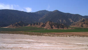
 Four
of the parcels share a boundary with the Los Padres National Forest, in
Santa Barbara and Kern counties near the intersection of Scenic
Highway 33 and the Maricopa Highway (Route 166). Two others are
within a half-mile of the forest boundary. Four
of the parcels share a boundary with the Los Padres National Forest, in
Santa Barbara and Kern counties near the intersection of Scenic
Highway 33 and the Maricopa Highway (Route 166). Two others are
within a half-mile of the forest boundary.
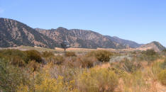
Many of these parcels are in
Santa Barbara Canyon, which serves as a
gateway leading into the northern portion of the Dick Smith Wilderness Area in the forest.
These lands are located in the
Upper Cuyama River Valley, which federal biologists have called
an "Area of High Ecological Significance" because of the
abundance of rare plants and animals here. According to the BLM,
this area is home to the endangered San Joaquin kit fox, the
threatened blunt-nosed leopard lizard, the threatened San
Joaquin antelope squirrel, the endangered California jewelflower,
and the endangered California condor.

The various
parcels proposed for auction are shown in bright colors and
numbered. The large light green area on the bottom half of the
map is the Los Padres National Forest. Highway 33 is shown in
red coming up from the bottom of the map and intersecting with
Highway 166.
ON THE AUCTION BLOCK: Cuyama River
3 parcels, 1,000 acres
Three parcels along the
banks of the Cuyama River are slated for auction. According to
the agency, these parcels are located in the
 floodplain
of this river. Oil drilling in a floodplain is not appropriate
due to the increased risk of oil spills into the river.
Drilling, access roads, and power lines would also interfere
with farmlands in the area that are currently under cultivation. floodplain
of this river. Oil drilling in a floodplain is not appropriate
due to the increased risk of oil spills into the river.
Drilling, access roads, and power lines would also interfere
with farmlands in the area that are currently under cultivation.
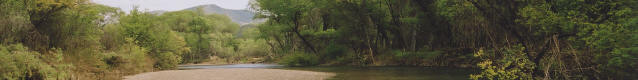
 Above: The Cuyama River, upstream from the auctioned parcel.
Photo © LPFW, Inc. Above: The Cuyama River, upstream from the auctioned parcel.
Photo © LPFW, Inc.
Left: The
map shows two of the three parcels (shown in purple and red).
The center of the Cuyama River bed is indicated by an orange
dotted line.
ON THE AUCTION BLOCK:
Carrizo Plain National Monument Bdy
4 parcels, 1,876 acres
Four parcels are located along
the eastern boundary of the Carrizo Plain National Monument, an
area set aside by Presidential Proclamation in 2001 to protect
one of the last remaining untouched ecosystems in the San
Joaquin Valley.
These parcels are home to the
threatened San Joaquin kit fox, the threatened San Joaquin
antelope squirrel, the threatened blunt-nosed leopard lizard,
and the endangered California condor.

ON THE AUCTION BLOCK: Bitter Creek National Wildlife
Refuge
2 parcels, 2160 acres
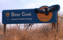 Slated for auction are two parcels
just outside the boundary of the Bitter Creek National Wildlife Refuge,
in the southwestern San Joaquin Valley foothills. The refuge
shares a boundary with the Los Padres National Forest. The
federal government purchased this 14,097-acre refuge in 1985 to
protect dwindling California condor foraging and roosting
habitat, and it's now protected as "critical habitat" for the
endangered bird. It's the site where the last female condor was
trapped in 1986 for the captive breeding program. Slated for auction are two parcels
just outside the boundary of the Bitter Creek National Wildlife Refuge,
in the southwestern San Joaquin Valley foothills. The refuge
shares a boundary with the Los Padres National Forest. The
federal government purchased this 14,097-acre refuge in 1985 to
protect dwindling California condor foraging and roosting
habitat, and it's now protected as "critical habitat" for the
endangered bird. It's the site where the last female condor was
trapped in 1986 for the captive breeding program.

OFF THE AUCTION BLOCK: Wind Wolves Preserve
4 parcels, 203 acres
In December, the BLM proposed
leasing four parcels located inside the Wind Wolves Preserve,
the largest privately-owned
nature preserve in
the West. The 97,000-acre preserve is located in the southern San Joaquin
Valley, adjacent to the Los Padres National Forest. The preserve is in an ecologically unique
region where the Transverse and Coast Ranges, Sierra Nevada
Mountains, western Mojave Desert, and San Joaquin Valley
converge.
We are happy to announce that
the BLM has removed these parcels from the lease sale. The Wind
Wolves Preserve is protected from additional oil drilling for
now.
What's Next
This auction comes on the
heels of a plan, approved in July, to open up 52,075 acres of
the Los Padres National Forest to oil drilling. The parcels up
for lease in December are outside of the forest, and not a part
of that plan. However, allowing drilling on lands right along
the forest boundary could eventually make it easier for oil
companies to expand their operations inside the forest.
The public comment period on
the Environmental Assessment for the June 2006 auction closes on
Saturday, April 22. ForestWatch is preparing a comment letter on
the agency's Environmental Assessment to ensure that the agency
fully analyzes the damage that could be caused by leasing in
these undeveloped areas.
After the agency reviews the
public comments, it could either (1) improve the environmental
impact study and re-issue it for further public comment, or (2)
approve the study as-is and conduct the auction as planned.
If the auction goes ahead as
scheduled, the oil company placing the highest bid wins
the right to drill for oil in the lease area. The oil company
may then conduct surveys, often using explosives or "thumper
trucks" to detect the location of oil. The company then submits
an Application for Permit to Drill and a Surface Use Plan of
Operations for approval. Once approved by federal agencies,
drilling can begin immediately.
|