|
November 14, 2005
Agency
Proposes to Auction Lands Near Forest Boundary for Oil Drilling
Parcels Are Located Along
Forest Boundary, a
National Wildlife Refuge, and a Nature Preserve
Bakersfield, CA - The Bureau of Land
Management (BLM) recently announced that it will conduct a
competitive lease sale that could pave the way for oil drilling
on sensitive lands near the Los Padres National Forest. Other
areas on the auction block include the Wind Wolves Preserve, the
Bitter Creek National Wildlife Refuge, and the Cuyama River.
The BLM will conduct the land auction on December
14 for 27 parcels of land totaling 19,053 acres in Santa
Barbara, Ventura, Kern, and San Luis Obispo counties.
During the lease sale, oil companies will be
able to bid on the rights to extract oil and gas from these
parcels. The sale is conducted much like an auction, with the
drilling rights going to the highest bidder. The minimum bid for an oil
lease is only $2.00 per acre.
|
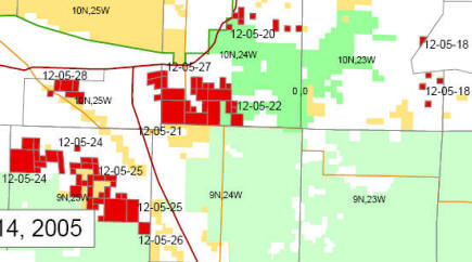
RED |
parcels
to be auctioned for oil and gas drilling |
|
LIGHT GREEN |
Los Padres
National Forest |
|
DARK GREEN |
Bitter Creek
National Wildlife Refuge
Critical Habitat for the California Condor |
WHITE AREA EAST
(RIGHT) OF BCNWR |
Wind Wolves
Preserve |
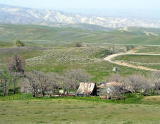
ON THE AUCTION BLOCK: Los Padres Forest Boundary
5 parcels, 5600 acres
 Five
of the parcels lie along the boundary of the Los Padres National Forest, in
Santa Barbara and Kern counties. These parcels are located on land
administered by the Bureau of Land Management, as well as
surrounding private lands. Five
of the parcels lie along the boundary of the Los Padres National Forest, in
Santa Barbara and Kern counties. These parcels are located on land
administered by the Bureau of Land Management, as well as
surrounding private lands.
Many of these parcels are in Santa Barbara
Canyon, approximately one mile west of the Cuyama River and
Highway 33. The road leading up Santa Barbara Canyon serves as a
gateway to the northern portion of the Dick Smith Wilderness Area in the forest.
Also along the forest boundary is a cluster of
parcels near Ballinger Canyon, between Highway 33 and the Bitter
Creek National Wildlife Refuge.
ON THE AUCTION BLOCK: Bitter Creek National Wildlife
Refuge
2 parcels, 2160 acres
 Slated for auction are two parcels
just outside the boundary of the Bitter Creek National Wildlife Refuge,
in the southwestern San Joaquin Valley foothills. Slated for auction are two parcels
just outside the boundary of the Bitter Creek National Wildlife Refuge,
in the southwestern San Joaquin Valley foothills.
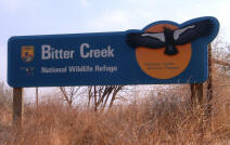
The federal government purchased this 14,097-acre
refuge in 1985 to protect dwindling California condor foraging
and roosting habitat. It's the site where the last female condor
was trapped in 1986.
ON THE AUCTION BLOCK: Wind Wolves Preserve
4 parcels, 203 acres
The agency will auction four parcels located
inside the Wind Wolves Preserve, the largest privately-owned
nature preserve in
the West. The 97,000-acre preserve is located in the southern San Joaquin
Valley, adjacent to the Los Padres National Forest.
The preserve is in an ecologically unique
region where the Transverse and Coast Ranges, Sierra Nevada
Mountains, western Mojave Desert, and San Joaquin Valley
converge.
ON THE AUCTION BLOCK: Cuyama River
1 parcel, 840 acres
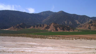 Also up for lease is one parcel along the
banks of the Cuyama River, and area that
the Forest Service has declared an "Area of High Ecological
Significance" due to the high number of rare plants and animals
here. Also up for lease is one parcel along the
banks of the Cuyama River, and area that
the Forest Service has declared an "Area of High Ecological
Significance" due to the high number of rare plants and animals
here.
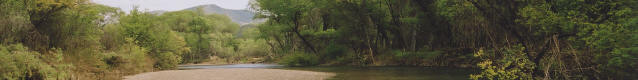
The Cuyama River, upstream from the auctioned parcel. © LPFW
This lease auction comes on the
heels of a plan, approved in July, to open up 52,075 acres of
the Los Padres National Forest to oil drilling. The parcels up
for lease in December are outside of the forest, and not a part
of that plan. However, allowing drilling on lands right along
the forest boundary could eventually make it easier for oil
companies to expand these operations inside the forest. This is
because once an oil well is
established in an area, additional oil wells can be
rubber-stamped in that area, with minimal environmental review.
What's Next
The oil company placing the highest bid wins
the right to drill for oil in the lease area. The oil company
may then conduct surveys, often using explosives or "thumper
trucks" to detect the location of oil. The company then submits
an Application for Permit to Drill and a Surface Use Plan of
Operations for approval. Once approved by federal agencies,
drilling can begin immediately.
|